From the parking area, proceed ahead (east) on Otterkill Road for 0.2 mile. About 150 feet before reaching the massive Moodna Viaduct (which spans the valley to the left), turn right onto a footpath, following the white-blazed Trestle Trail, which proceeds uphill rather steeply on a woods road, with the Moodna Viaduct to the left.
In about 500 feet – just before reaching the level of...

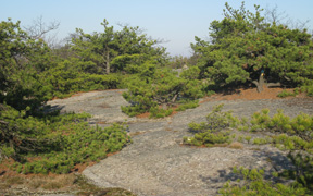
 You’ve now reached the ridge of Schunemunk Mountain, which is composed of a conglomerate rock, studded with pebbles of white quartz and pink sandstone. This unusual rock has been smoothed by glacial action, sometimes resembling a level sidewalk. After 0.3 mile of this ridge-walking, you will come to a large open area studded with pitch pines. You’ll notice a line of cairns (rock piles) which lead to the right; follow them into a wooded area, and you will soon arrive at the Megaliths – a group of huge blocks that have split off from the bedrock. This is a good place for a break, as the interesting geologic features are complemented by a fine viewpoint to the west.
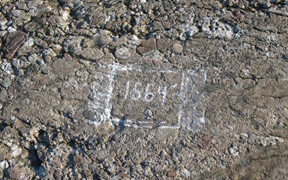
 mountain. The elevation (1,664 feet) is painted on the bedrock, and there are good views from this spot. You can see the Perkins Tower atop Bear Mountain to the southeast, with the Shawangunk Ridge visible to the northwest, and the Catskills beyond. In another 500 feet, you’ll pass the terminus of the Ridge-to-Ridge Trail (blue on white) to the right.
